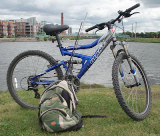
Though most serious cyclists prefer road bikes, my primary concern when biking is comfort. I'll gladly give up speed and the ability to ride 100 km days for the comfort of my double suspension mountain bike. Though you lose some cranking power when pedaling hard or going uphill, I don't need to concern myself with wearing those funny looking padded shorts, nor with my bike shattering to pieces riding over our terrible roads or rougher trails.
In comparison to my other workout circuits, biking / cycling has proven the most effective for weight loss. During extended periods of time where I was forced to stay away from weights due to injuries, I lost a decent amount of weight simply putting in more time on my bike.
For motivation, I time my rides, trying to beat my previous bests for any given trail almost every time I ride. Keeps me pushing and panting, especially when riding uphill. Beating a previous record every now and then re-assures me that I'm on the right path to staying fit.
Living not too far from Mount Royal, I incorporate a decent amount of uphill trails into most of my cycling hours. The mountain itself has a nice wide trail all the way around it, and there are various roads that cut through the different slopes and peaks.
My favorite ride is cutting through the Notre Dame des Neiges cemetery from Decelles, then exiting it at Camillien Houde, right across Beaver Lake. From there it a few minutes ride up to the peak where the radio towers are, via the Mount Royal trail (Chemin Olmstead).
See map at: https://www.google.ca/maps/@45.5022677,-73.5934084,546m/data=!3m1!1e3
Typically stop to stretch on my way back down at the Chalet Du Mont Royal lookout.
Other decent rides up and down other segments of Mount Royal go through the upper scale residential areas of Westmount. Ascending from the North slope, Victoria, to Sunnyside, to Gordon Crescent, will lead you to Summit Circle. Not as long of a ride from where I live near Decarie / Van Horne, but a bit more of an intense uphill ride.
See map at: https://www.google.ca/maps/@45.4919185,-73.6100944,640m/data=!3m1!1e3
Lastly, most of the roads going South from the Boulevard are quite steep. Very quick acceleration downhill, and a short but intense uphill on any of the roads between Grosvernor and Clarke once you pass Sherbrooke and climb back up.
Aside from the mountain trails, I often combine biking with fishing. I can hit the Lachine canal trail within less than 25 minutes, and although fishing there is tough, I am able to run and gun many spots within an hour or so, just perfect for a short bike n fish break during my work day. Biking to the canal and back involves climbing Mount Royal with some fishing gear on my back, which ads to the workout.
The Lachine Canal trail runs about 12.5 kilometers from it's starting point on the Lachine/Lasalle border, and runs along the canal into Old Montreal. The trail tens to get very busy on weekends, so I try to bike it only during the week during work hours during peak season. Various waterfront parks to stop at along the way, a bike rental/repair shop, and of course, plenty of spots to cast your line. The canal is accessible from various points, I typically hit it by climbing Mount Royal, crossing lower Westmount into Ville St Henri, than then heading West towards Ville St Pierre, or East towards Little Burgundy. See map at: https://www.google.ca/maps/@45.4589907,-73.6019523,13.47z
Alternatively, I can fish the Riviere des Prairies by crossing St Laurent and Cartierville, a bit more of a steady flat ride without much incline. Less scenic, but still a good cardio workout. Gouin Boulevard runs along the waterfront, and certain segments of it further East have some bike trails.
The South shore trail intermittently runs along the St Lawrence River though Brossard and La Prairie.
See map at: https://www.google.ca/maps/@45.480524,-73.5064053,15.97z
The Soulanges Canal bike trail West of Montreal Runs 24 KM from Pointes Des Cascades to Les Coteaux (Coteaux Landing). Scenic paved trial runs along the South side of the canal trhough wooded area, much less bike or foot traffic than the Lachine Canal trail.
See map at: https://www.google.ca/maps/@45.3288924,-74.1091795,12.5z
Lastly, the longest dedicated bike trail in our region is the Linear park / Ptit train du Nord, that runs 200 KM from St Jerome up to Mont Laurier. Originally an old rail track, it was turned into a bike trail after the trains stopped running. Much of it is a well managed dirt trail, though the Northern segments are paved. It runs mainly through forest, with some very scenic rivers and lakes along the way. As it passes through many small villages, stopping for a bite, drink or other leisure activities, is only minutes away. A yearly access fee of $15 is no longer in effect, so it's free to ride.
View their web and interactive map with a list of points of interest along the trail at:
http://www.laurentides.com/en/linear-park/maps-train-stations-and-parking-0


I've read a few of your post and I am on a similar journey. I'm a mother of a two year old and have had a difficult time losing weight or being motivated enough to lose weight. I'd love for you to read some entries. I'm new to the blogging world but any advice, criticism, or inspiriting words would be great. Love your stuff
ReplyDeleteSure, you can reply with your blog link or send to plumbroso@gmail.com
Delete